
Landscape Comparison Technique Bridges Data Gaps in Global Forest Monitoring
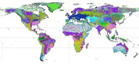 To understand how forests are responding to global change, a global effort is required. A vast forest research network, known as the Center for Tropical Forest Science-Forest Global Earth Observatory (CTFS-ForestGEO), is advancing this understanding with standardized forest monitoring activities in 59 forests in 24 countries across the world. Since data are not available in every country, researchers must employ methods to reach large-scale conclusions about changing forests. Eastern Threat Center research ecologist Bill Hargrove and partners have contributed to CTFS-ForestGEO with a technique developed to compare similar landscapes based on climate, soils, and topography. Their work has enabled a description of the forest types represented (or underrepresented) in the CTFS-ForestGEO network’s findings, which have been published in the journal Global Change Biology and summarized in a Smithsonian news release.
