
More than the sum of their parts: regional assessment tools work better together
The Forest Service and its partners have produced many regional assessments that provide information about conserving habitats, clean water, timber and non-timber resources, and other ecosystem services. Renewed collaboration with National Forests in the Southeast is enabling approaches that pull together information from these many sources to give a full picture of forest landscapes, the threats they face, and how best to conserve the many benefits they provide.
 Recent articles in CompassLive and in the Ecoforesters Newsletter highlighted ecological assessment as a key tool for understanding the role of forests in providing a wide variety of benefits to society. Synthesis of regional assessments can help capture the complexities of whole landscapes while providing clarity to decision-makers when multiple values and management goals are at stake. The Landscape-Level Integration and Shared Stewardship initiative is a regional Forest Service effort to enhance the use of best available science in adaptive landscape management. Scientists engaged in this effort are developing tools that integrate existing assessments to aid in large-scale ecosystem management decision-making.
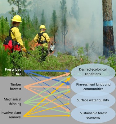
Pictured: A variety of forest management tools are used in Southern landscapes to help achieve a variety of goals. These tools have different impacts, and applying them well depends on rich ecological and societal information. Integrating multiple forest assessment approaches into planning can help in applying the right tools to achieve the best outcomes. USDA Forest Service image.
