
Partners use HiForm to map dead pines
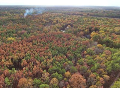 Late last year, the South experienced an extremely hot and sudden drought. When temperatures are high and moisture is low, trees become vulnerable quickly. Across southwest Mississippi and eastern Louisiana, approximately 12 million pine trees began dying, and by early winter, 83,000 acres of pines had died. That estimate was derived with HiForm, a Southern Research Station tool developed by Threat Center scientists Steve Norman and Bill Christie. The use of HiForm mapping products by state forestry agencies to assess the damage to pine forests is highlighted in a new SRS news feature. “HiForm is revolutionizing the way we monitor forests,” says Norman. “These technologies let us track forest health throughout the year and capture sudden disturbances in near-real-time.”
Read the News Feature.
View an online map of recent pine mortality in Mississippi.
