
Threat Center helps Mississippi Forestry Commission map pine mortality
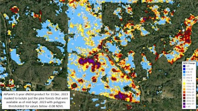 A Mississippi news story in The Daily Leader (Brookhaven, MS) reported on a collaboration between Threat Center scientists and the Mississippi Forestry Commission, bringing Threat Center science to bear on a pressing problem. Historic drought conditions in southeastern and central Mississippi have created conditions favorable for outbreak of pine beetle infestations, leading to widespread pine tree mortality. To respond effectively, managers need timely information about where the impacted areas are--whether on private or public lands. Threat Center researchers Steve Norman and Bill Christie worked with the Forestry Commission to deliver a highly accurate and detailed map of likely pine mortality associated with the recent drought and insect outbreaks. This research relies on remote sensing based techniques developed by the HiForm (High-resolution Forest Mapping) project.
Read the Daily Reader's news story.
View the online map of recent pine mortality in Mississippi.
Visit the HiForm website for details about the mapping effort and other projects.
