
Forest ThreatNet
Mapping fire regimes with shared characteristics across the globe
While ecosystems can vary dramatically around the world, many far-flung regions share similar fire regimes. Mapping fire regimes worldwide and understanding these similarities can help direct the transfer of ecological insights about fire effects from one region to another, and can facilitate the exchange of successful fire management strategies worldwide.
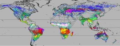
Fire, whether wild or controlled by people, is characteristic of most of the world’s terrestrial ecosystems—even if it is quite rare in some. Mapping how different ecosystems around the world may share similar fire regimes (or ‘Global Fire Regimes’—GFRs) is an important step toward a shared understanding of fire management and living with fire during a time of global change. Research by SRS scientists is helping to uncover GFRs, using satellite observation data and advanced statistical methods to handle large and complex data at the global scale. The team used millions of ‘hotspot’ thermal detections from 2002 to 2019 from the MODIS satellite sensors to describe fire intensity, return frequency, and seasonality. Resulting maps are colored to show regions that share similar fire conditions, and color gradients show which fire characteristics change across the map. This includes fire behaviors such as when they normally occur in the year—and a novel method makes GFRs consistent across both northern and southern hemispheres, even though their seasons come at different times of year. This research has shown that while a few GFRs are unique, the majority are shared with other regions somewhere in the world. Most GFRs have two times of year when fires are most frequent, often at the beginning and end of the growing or rainy season. Finally, many GFRs are human-dominated, such as those indicating swidden agriculture or deforestation.
« Previous page Next page » Return to contents
