
Forest ThreatNet
FIRST Offers Broad View of Forest Threats
Advanced technology holds key to early warning system
By Bridget O'Hara, NEMAC Deep in a 10,000 acre forest a small insect is chewing holes in canopy leaves. It is nothing a forest manager will give a second thought. That is unless that bug has 10,000 offspring that thrive and completely defoliate a 20 acre hole in the canopy. Research ecologist William “Bill” Hargrove has always been interested in these types of interactions that ocurr at the intersection of species. Now, rather than examining holes insects chew in leaves, he is creating a tool that will allow forest managers to spot changes on a continental scale.
Above right: EFETAC research ecologist Bill Hargrove's Forest Incidence Recognition and State Tracking system will help forest managers detect changes on a continental scale.
Hargrove and his EFETAC colleagues are developing an early warning system that utilizes satellite imagery to detect changes in the landscape. The Forest Incidence Recognition and State Tracking (FIRST) will combine the imagery of the entire U.S. from the Moderate Resolution Imaging Spectroradiometer (MODIS) sensor on the terra and aqua satellites with other data on climate, topography, and soils to identify potential forest and wildland threats.
The continental images are comprised of over 32 million cells, each covering approximately 62 acres of U.S. landscape. FIRST will computationally process and classify all imagery and other ecological data, and identify changes that have occurred during the previous 8-day interval. Some changes are normal, expected seasonal, or human-induced changes. For example, fall and spring will bring many expected changes in leaf color and canopy cover. Hargrove intends to have the alert system automatically overlook these expected changes, concentrating instead on unusual or unexpected changes that may represent locations having potential forest threats.
 Hargrove hopes this system will help forest managers identify large scale forest changes faster. Currently, managers check the health of forests through visual surveys. Not intended as a substitute for visual surveys, FIRST will give ground and airborne surveys an added advantage. “FIRST will highlight areas on a map that are possible alerts,” he says, “and then forest managers can use overflights, sketchmapping, and people on the ground to confirm and determine the nature and severity of the threat.” Hargrove continues, “We hope that FIRST will be of interest not only to forest managers, but also for food and farm production, and even social scientists studying human settlement and living patterns.”
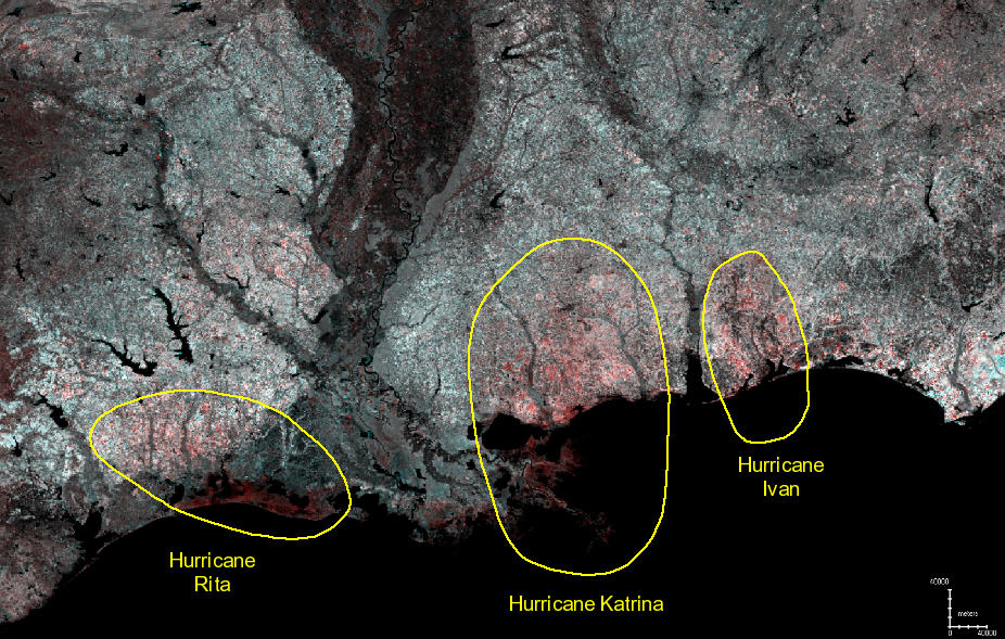
Above: The FIRST system will simplify the analysis and impacts from forest threats over large regions. Here, the lasting effects from hurricanes Rita, Katrina, and Ivan can be seen in a single analysis as a reduction in the 20 percent maximum leaf phenology.
Much still needs to be done before FIRST will be available to researchers, managers and the public. Along with NASA's Stennis Space Center colleagues and sister center, the Western Wildland Environmental Threat Assessment Center, EFETAC has developed national data sets on leaf phenology, or seasonal vegetation changes, from the MODIS data as one type of input to FIRST. Historical timing of leaf phenology can provide FIRST with many clues to vegetation status and health. Layers like temperature, precipitation, soils, and topography will also be added as inputs, adding to the types of changes FIRST can detect.
Hargrove emphasizes, “We hope to back-calculate all FIRST products every 8 days to the beginning of the MODIS period, which started in 2000. By providing a standardized analysis rather frequently for many years, the FIRST system should provide a monitoring baseline against which many changes can be measured, making it of interest to lots of potential users.”
These types of analyses are computationally intensive, and Hargrove does not expect to go into full production just yet. “The FIRST system is still being designed, developed, and tested, but we hope to have the first large analyses done before the year’s end.”
« Previous page Next page » Return to contents
