
Forest ThreatNet
Journal Highlights Forest Service Early Warning System
 A national early warning system designed to assist land managers in rapidly detecting threats to forest health was featured in the cover article of the October 2009 issue of Photogrammetric Engineering and Remote Sensing (PE&RS), the journal of the American Society for Photogrammetry and Remote Sensing (ASPRS). The article, entitled “Toward a National Early Warning System for Forest Disturbances Using Remotely Sensed Canopy Phenology,” describes the vision and progress of the system in development by partners from EFETAC, Western Wildland Environmental Threat Assessment Center, and NASA Stennis Space Center.
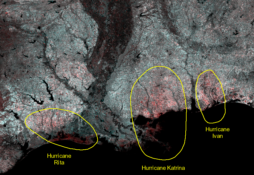
Above: The early warning system will simplify analysis of impacts from forest threats over large regions. Lasting effects from hurricanes can be viewed as a reduction in vegetation.
The initial stages of the early warning system include use of satellite imagery in combination with aerial and on-the-ground observations to monitor forest health. The next stage, and a key component of the system, is the incorporation of data on land surface phenology—the expected seasonal vegetation changes such as spring leaf out and fall leaf color change and drop—to create weekly maps of U.S. vegetation (e.g., forest) change.
 “Land surface phenologies can be used to characterize normal, ‘expected’ conditions and thus can help a warning system determine where and when vegetation has changed,” says William Hargrove, EFETAC research ecologist and lead author of the PE&RS article. “The goal of this system is to allow analysis of vegetation change on a weekly basis at a national scale to provide near real-time information on forest conditions as they are impacted by insects, diseases, wildfires, or extreme weather events.”
Right: William Hargrove
Researchers are employing the MODIS (Moderate Resolution Imaging Spectroradiometer) satellite to generate the land surface phenology data that underlie the weekly landcover maps. “Work thus far has been promising,” says Joe Spruce, a senior scientist working at NASA Stennis Space Center. “We can clearly detect regional patterns of forest disturbance from the MODIS data.” Soon, land managers and other interested users will be able to access these disturbance detection products online. “We think that timely regional forest change detection products in a format that is easily accessible will help provide new, previously unavailable early warnings of prevalent forest threats. This application will enable new ways to monitor vital signs of forests and to respond where threats occur,” says Spruce.
For more information about the early warning system or to view the PE&RS article online, contact Bill Hargrove at (828) 257-4846, by email at william.w.hargrove@usda.gov or visit www.forestthreats.org.
« Previous page Next page » Return to contents
