
Forest ThreatNet
EFETAC Supports Regional and National Research Efforts
by Alan Ager, WWETAC
The West-Wide Climate Change Mapper
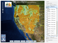 WWETAC developed a suite of mapping tools to facilitate wildland threat assessments. The Climate Change Mapper, a browser-based mapping system, provides a simple and convenient portal to downscaled climate change data.
The system currently contains climate change data generated by the Climate Impacts Group at the University of Washington. This downscaling effort was funded by a consortium of federal agencies (Forest Service Northern and Pacific Northwest Regions, US Fish and Wildlife Service, and the US Forest Service Rocky Mountain Research Station Boise Aquatic Sciences Lab). The data are intended for regional planning and assessments.
The Climate Change Mapper can be accessed at http://www.fs.fed.us/wwetac/threat_map/index.html.
Above: The Climate Change Mapper displays over 100 data layers showing projected changes from historical (1916-2000) conditions to the mid-century (2030-2059).
The Western Threat Center also has a number of other geospatial tools, including the Threat News Explorer and the Geospatial Search Engine. The Threat News Explorer is a customized media search engine that locates and maps news stories on major forest threats, including wildfires, bark beetles, climate change, and other forest disturbances. The Geospatial Search Engine is a data mining tool that searches the internet for spatial data based on user-input keywords.
The Threat News Explorer is a customized media search engine that locates and maps news stories on major forest threats, including wildfires, bark beetles, climate change, and other forest disturbances. The Geospatial Search Engine is a data mining tool that searches the internet for spatial data based on user-input keywords.
For more information on these and other WWETAC geospatial tools, please contact Alan Ager, aager@fs.fed.us, or Charlie Schrader-Patton at cschrader@fs.fed.us.
WWETAC Researchers Examine Wildland Urban Interface Fire Options
 WWETAC researchers Alan Ager and Nicole Vaillant published a study examining tradeoffs between prioritizing treatments to protect the wildland urban interface (WUI) versus landscape restoration to create fire resilient forests.
Ager and Valliant modeled a range of fuel management scenarios that placed WUI treatments around structures versus in the surrounding landscape to accomplish forest restoration objectives. Restoration scenario results showed that treating as little as ten to fifteen percent of the study area could diminish the loss of old growth trees by about 70 percent. Most importantly, simulations predicted that treatments three to six miles away from the WUI could substantially lower the chances of a wildfire reaching homes and other structures.
As expected, treating forest stands in and around the WUI lowered the likelihood of burning around structures, but this outcome was accompanied by higher expected losses of large trees in the adjacent national forest. The researchers concluded that the perceived difference between protecting the WUI and dry forest restoration is due to the lack of landscape analyses of large fire behavior in previous studies. Both goals can be achieved in many instances by careful design of fuel treatment projects in the interface along with appropriate homeowner practices to reduce fuels in the home ignition zone.
The study represents a step toward building optimal fuel management to identify the most cost-effective ways to allocate funding for fire management. "Our hope is that policymakers can use our findings to develop new budget directions that will serve to encourage the designing of fuel treatment programs that consider broad landscape factors and meet multiple objectives, beyond single-issue risk mitigation," Ager says. "The study results should also be useful to planners in justifying the allocation of funds targeted for WUI protection for meeting wider ecological restoration goals with respect to wildfire and biodiversity conservation."
The paper can be found, along with similar fuel management studies, at www.arcfuels.org under "Case Studies."
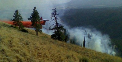
Above right: Air tanker dropping retardant on the 2009 Huckleberry Fire with the Mt. Emily WUI study area in the background. Photo courtesy of Amber Mahoney, Umatilla National Forest.
Enhanced TACCIMO Tool Supports Eastern and Western Decision Makers
The Eastern and Western Threat Assessment Centers and partners in the Forest Service’s Southern and Pacific Southwest Regions have enhanced the web-based Template for Assessing Climate Change Impacts and Management Options (TACCIMO).
TACCIMO links climate change forecasts, ecosystem impacts, and management options through a customized reporting format relevant to forest planners and managers within the Forest Service, other federal and state agencies, and non-governmental organizations.
New TACCIMO content represents natural resource issues in the eastern and western United States through an expanded and searchable climate literature database, streamlined reporting functionality, and additional support and training resources.
Visit http://www.forestthreats.org/tools/taccimo to learn more.
« Previous page Next page » Return to contents
