
2013 Research Highlights
ForWarn Expands US Forest Disturbance Detection and Tracking Capabilities
Web-based tool improves near-real-time and long-term US forest monitoring
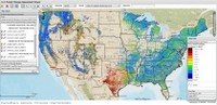 To help forest and natural resource managers rapidly detect, identify, and respond to unexpected changes in the nation’s forests, scientists and collaborators with the Eastern Forest Environmental Threat Assessment Center and the Pacific Northwest Research Station Western Wildland Environmental Threat Assessment Center, have developed and refined ForWarn, an internet-based forest monitoring and assessment tool that uses NASA satellite data. Since its release in 2010, ForWarn has successfully detected and mapped the severity and extent of disturbances including tornadoes, wildfires, hurricane impacts, hail damage, insect defoliations, development, and extreme drought. ForWarn produces sets of national maps that show potential forest disturbances every 8 days by comparing current forest vegetation greenness with different baseline maps of historical greenness for a specific location and day of the year. With help from recently added baselines, ForWarn now captures recent disturbances almost immediately after they occur while detecting slow-acting change in greenness since 2000 in spite of weather influences. This flexibility in monitoring disturbance and recovery using recent to multiple year contexts provides a richer national overview of forest health that can better focus and prioritize rapid response and other management efforts.
ForWarn is the first national-scale system of its kind developed specifically for forest disturbances. In coming months, ForWarn will be providing access to potential disturbances in rangeland vegetation and agricultural crops. ForWarn is the result of ongoing cooperation among federal and university partners and can be accessed at http://www.forwarn.forestthreats.org.
Right: ForWarn's Forest Change Assessment Viewer provides forest disturbance maps every eight days.
Forest Service Partners/Collaborators: Western Wildland Environmental Threat Assessment Center; Forest Health Monitoring Program
External Partners/Collaborators: NASA Stennis Space Center; US Department of Energy Oak Ridge National Laboratory; US Geological Survey EROS Data Center; University of North Carolina Asheville’s National Environmental Modeling and Analysis Center
Contact: William W. Hargrove, Eastern Threat Center research ecologist, (828) 257-4846, william.w.hargrove@usda.gov
