
ForWarn Provides New Insight into Duration and Impacts of Forest Disturbances
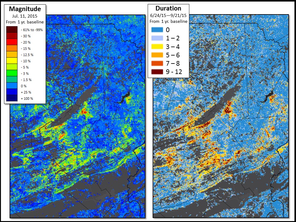 Quantifying the magnitude of a disturbance to forest vegetation is of primary importance in forest health monitoring; however, the duration, or how long that disturbance lasts, is equally important for determining the full impact to vegetation health. To date, all products from the ForWarn monitoring and assessment system have measured the instantaneous magnitude of vegetation disturbances, using satellite data to quantify the amount of damage to leaves in a 232-square meter map cell (about 13 acres), yet a full accounting of disturbance impacts also requires knowing how long the damage to those leaves was present. To provide insight into disturbance duration, ForWarn researchers have developed a new seasonal forest monitoring product that distinguishes ephemeral (short-lived) disturbances from lasting disturbances. For example, storms, insect defoliations, and light fires are common in the early growing season, but sometimes trees can quickly refoliate, causing even the most extreme damage to diminish by mid-summer. Where damage involves more than the leaves, effects can be more lasting. The new ForWarn disturbance duration products are designed to measure those nuances, as well as help forest managers see past lingering obstacles to satellite imagery, such as persistent cloud cover. ForWarn researchers currently produce disturbance duration products three times during each growing season.
Pictured: ForWarn allowed researchers and managers to monitor the magnitude (left) and duration (right) of damage from the 2015 gypsy moth outbreak in Pennsylvania. For every map cell, duration of the disturbance over the growing season is shown as the number of weekly ForWarn map products showing damage exceeding a particular threshold when compared to the previous year’s vegetation. Click to enlarge.
Forest Service Partners/Collaborators: Western Wildland Environmental Threat Assessment Center
External Partners/Collaborators: NASA Stennis Space Center; Department of Energy Oak Ridge National Laboratory; University of North Carolina Asheville National Environmental Modeling and Analysis Center; U.S. Geological Survey Earth Resources Observation and Science Center
Contact: William Hargrove
