
ForWarn II: A Familiar Monitoring and Assessment Tool is Reborn
Upgrades to ForWarn’s Forest
Change Assessment Viewer provide new views of vegetation change across the
United States and beyond.
 For seven years, users have relied on the ForWarn monitoring and
assessment tool for detecting and tracking potential vegetation disturbances in near-real-time across
the conterminous United States. In 2018, the ForWarn development team from the Eastern
Forest Environmental Threat Assessment Center completed a major ForWarn upgrade,
known as ForWarn II, which expanded coverage to lands across boreal Canada,
Mexico, and most of the Caribbean. In addition to its existing suite of data
and map products, a new ForWarn II product maps the progress in green-up and
brown-down of vegetation relative to an 18-year history of satellite records.
This “Seasonal Progression Departure” product highlights areas that are
experiencing an early or late growing season due to inter-annual variability—important
information for distinguishing year-to-year vegetation changes from true
disturbances or long-term shifts in forest conditions. All ForWarn II products
are available through the Forest Change Assessment Viewer,
accessible through any web browser and computer (including tablets and smart
phones) with no registration or password required. As always, users can click
on any location on a map to see its 18-year history of seasonal vegetation changes
and gain management insights into its past ecological history. The ForWarn
development team continues to generate data and map products in the computing
“cloud” every eight days to minimize production costs, and issues alerts to
managers working in or near areas observed to have potential vegetation
disturbances. They plan to further expand the coverage of ForWarn II to include
lands across Alaska, Hawaii, and all of Central America.
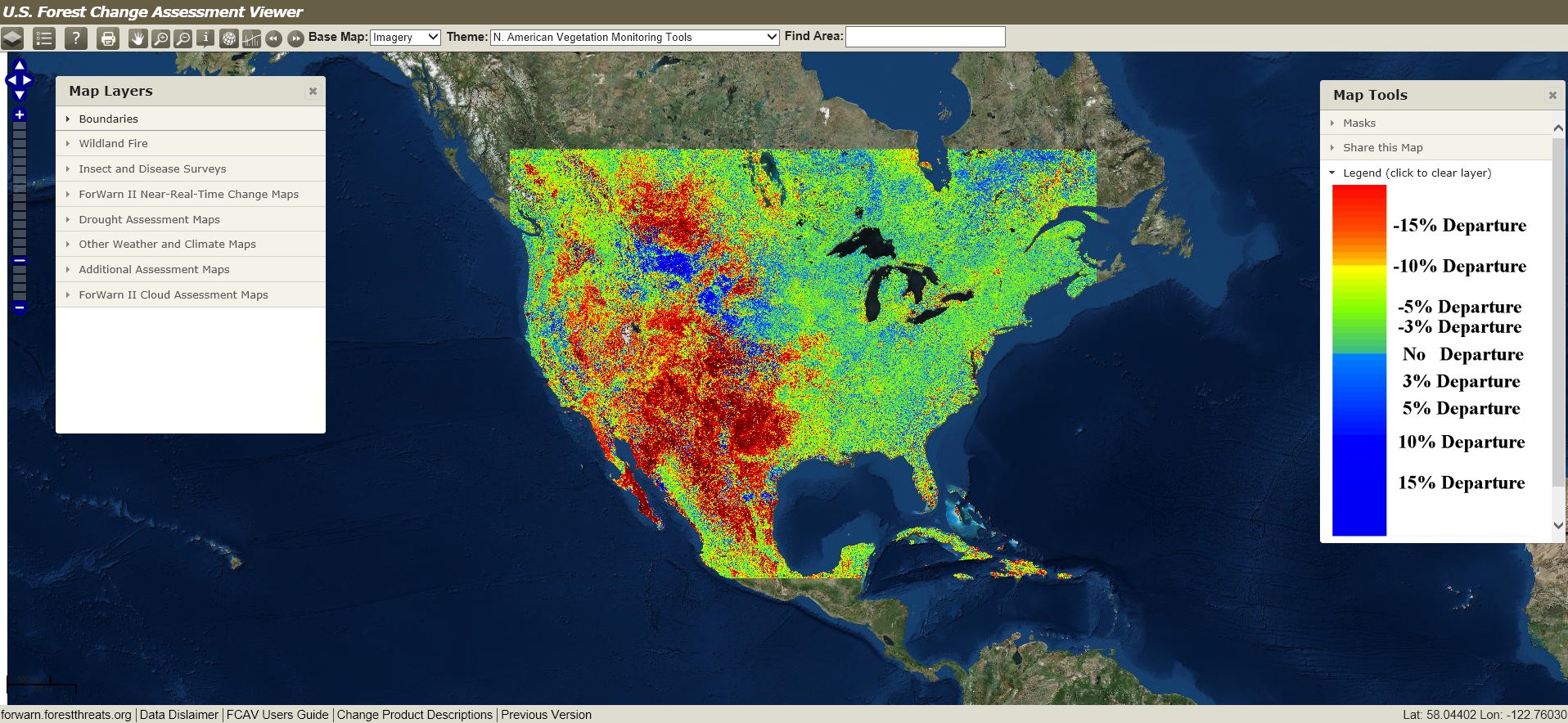
For seven years, users have relied on the ForWarn monitoring and
assessment tool for detecting and tracking potential vegetation disturbances in near-real-time across
the conterminous United States. In 2018, the ForWarn development team from the Eastern
Forest Environmental Threat Assessment Center completed a major ForWarn upgrade,
known as ForWarn II, which expanded coverage to lands across boreal Canada,
Mexico, and most of the Caribbean. In addition to its existing suite of data
and map products, a new ForWarn II product maps the progress in green-up and
brown-down of vegetation relative to an 18-year history of satellite records.
This “Seasonal Progression Departure” product highlights areas that are
experiencing an early or late growing season due to inter-annual variability—important
information for distinguishing year-to-year vegetation changes from true
disturbances or long-term shifts in forest conditions. All ForWarn II products
are available through the Forest Change Assessment Viewer,
accessible through any web browser and computer (including tablets and smart
phones) with no registration or password required. As always, users can click
on any location on a map to see its 18-year history of seasonal vegetation changes
and gain management insights into its past ecological history. The ForWarn
development team continues to generate data and map products in the computing
“cloud” every eight days to minimize production costs, and issues alerts to
managers working in or near areas observed to have potential vegetation
disturbances. They plan to further expand the coverage of ForWarn II to include
lands across Alaska, Hawaii, and all of Central America.Pictured: ForWarn II’s Forest Change Assessment Viewer allows users to interact with forest change map products and to share and collaborate with colleagues regarding current and historical forest disturbance.
Related links:
- ForWarn II
- ForWarn II Forest Change Assessment Viewer
- Highlights of satellite-based forest change recognition and tracking using the ForWarn system
Contact: William Hargrove (PI), Research Ecologist, william.w.hargrove@usda.gov; Steven
Norman, Research Ecologist, steve.norman@usda.gov;
William Christie, Biological Scientist, william.m.christie@usda.gov
