
Researchers Assessing Landscape Change Around Southeastern Wood Pellet Mills
The market industry for wood pellets exported from the United States is undergoing a boom phase that began in the year 2000, due to a strong demand for pellets in Europe as an alternative to coal for energy production. This increased demand has revived a number of defunct sawmills throughout Georgia, South Carolina, North Carolina, and Virginia for the purposes of pellet production. Landscape ecologists are using forest inventory, satellite, and commercial data to answer questions on where pellet mills have been the most successful and where they have influenced discernable landscape change.
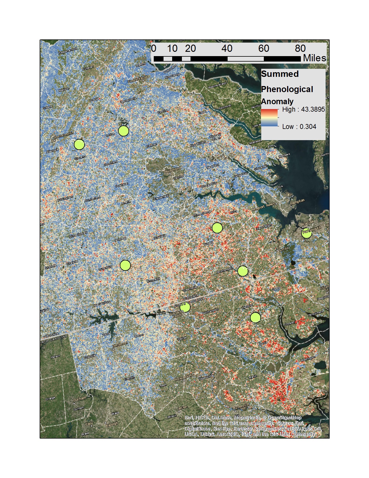 Scientists from Oak Ridge National Laboratory are leading a Department
of Energy-funded task to evaluate the environmental, social, and economic
sustainability of southeastern U.S. wood pellet production. Forest Service
researchers from the Eastern Forest Environmental Threat Assessment Center and
Forest Inventory and Analysis (FIA) program are collaborating on the project to
provide greater context to environmental and economic changes observed in the
vicinity of 19 pellet mills that have exported wood pellets through the
Chesapeake and Savannah seaports. As a pilot study, the researchers are examining
signals of change and the degree to which ongoing changes can be attributed to
activity associated with the mills. Using the Forest Service’s Landscape Dynamics
Assessment Tool (LanDAT), researchers are extracting satellite-based measures
of total seasonal canopy change (phenology) within the radius of areas
potentially sourced for wood pellets as determined from FIA data. Results from
this study promise to lead to improvements in knowledge about how and where
pellet mills may contribute to shifts in landscape dynamics and related
ecosystem services.
Scientists from Oak Ridge National Laboratory are leading a Department
of Energy-funded task to evaluate the environmental, social, and economic
sustainability of southeastern U.S. wood pellet production. Forest Service
researchers from the Eastern Forest Environmental Threat Assessment Center and
Forest Inventory and Analysis (FIA) program are collaborating on the project to
provide greater context to environmental and economic changes observed in the
vicinity of 19 pellet mills that have exported wood pellets through the
Chesapeake and Savannah seaports. As a pilot study, the researchers are examining
signals of change and the degree to which ongoing changes can be attributed to
activity associated with the mills. Using the Forest Service’s Landscape Dynamics
Assessment Tool (LanDAT), researchers are extracting satellite-based measures
of total seasonal canopy change (phenology) within the radius of areas
potentially sourced for wood pellets as determined from FIA data. Results from
this study promise to lead to improvements in knowledge about how and where
pellet mills may contribute to shifts in landscape dynamics and related
ecosystem services.
Pictured: A digital map derived from the Landscape Dynamics Assessment Tool (LanDAT) shows the total amount of canopy change in forested lands within the Chesapeake “fuelshed” across eastern North Carolina and Virginia. The green circles indicate the locations of pellet mills. Red areas indicate forests that have undergone the strongest shift in forest canopy from 2000–2015.
Related links:
Forest Service Partners/Collaborators: Forest Inventory and Analysis
External Partners/Collaborators: Oak Ridge National Laboratory
Contact: Bjorn Brooks, Ecologist, bjorn-gustaf.brooks@usda.gov
