
Monitoring forest health during a pandemic: satellite-based remote sensing fills a crucial gap
Remote sensing technologies that monitor forest disturbances have taken a giant leap forward just when they’re needed the most – during the Covid-19 pandemic.
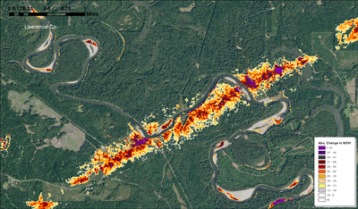 Assessing damage from natural disturbances is an ongoing need for state and federal forest managers. Before the 2020 growing season began in the South, tornadoes struck from Texas to North Carolina. Two sequential frosts set back the growing season across Tennessee, Kentucky, and Virginia. As the summer went on, vast sections of Michigan and New York were defoliated by the nonnative gypsy moth, then hurricanes inundated low lying areas of the South.
For decades, the USDA Forest Service and state agencies have tracked disturbances such as these in partnership, primarily through aircraft and ground observations. Those capabilities were curtailed in 2020 by coronavirus restrictions. The forest monitoring mission would need to rely on existing and new remote sensing technologies during the pandemic.
Southern Research Station researchers stepped up to this challenge by working closely with state and federal partners to ensure maximum use of existing ForWarn products and the new HiForm workflow that makes use of high-resolution satellite imagery. Researchers worked closely with partners to map damage and build capacity through free sharing of analysis tools and one-on-one exchange. This communication helped managers track disturbances and provided additional insights for the researchers. Given the long-term cost savings and safety benefits of rapidly evolving remote sensing technologies, this intense 2020 team effort should continue to reap rewards for years to come.
Contact: Steve Norman, William Christie, and William Hargrove, Eastern Forest Environmental Threat Assessment Center. steve.norman@usda.gov. william.m.christie@usda.gov. william.w.hargrove@usda.gov
