
2011 Research Highlights
Predicting Future Suitable Habitat Locations for North American Tree Species
ForeCASTS project targets at-risk tree species for monitoring, conservation, and management
 Climate change poses a severe threat to the viability of several forest tree species, which may be forced either to adapt to new conditions or to shift their ranges to more favorable environments; species with limited geographic ranges are at highest risk. To help natural resource managers, land-use planners, and conservation organizations target tree species for monitoring, conservation, and management activities, EFETAC scientists are using spatial models of future environmental conditions to predict and map the location and quality of habitat for several hundred North American forest tree species. Known as the Forecasts of Climate-Associated Shifts in Tree Species (ForeCASTS) project, scientists are also determining where each species, within its current range, is most susceptible to extinction as a result of climate change.
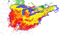
Scientists have mapped global range shifts for 215 tree species under different climate change models and emissions scenarios for the years 2050 and 2100. Most species' predicted suitable ranges closely follow or are slightly more extensive than actual ranges under present conditions. ForeCASTS also includes maps of Minimum Required Movement that detail the closest geographic locations, or “lifeboat” areas, offering future suitable habitat conditions and show the likelihood of local extinction following climate change. The ForeCASTS maps can be viewed at http://www.forestthreats.org/tools/ForeCASTS.
Contact: William W. Hargrove, research ecologist, (828) 257-4846, william.w.hargrove@usda.gov
