
Forest Pest Risk Maps Reveal Uncertainties
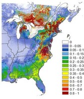 Pest risk maps are intended to show decision makers which locations face the greatest risk of invasion by a pest, allowing them to prioritize scarce monitoring and management resources. Uncertainty is an inevitable aspect of the risk mapping process, as it arises from sources including spatial data and model parameter values used to construct the map. Commonly, these various uncertainties are downplayed or omitted from final risk map products, which may lead map users to make incorrect management decisions. Scientists and collaborators with the Eastern Threat Center have pioneered new methods for representing uncertainty in invasive species risk maps, improving the maps’ utility for decision support.
The work has been presented in several journals. A recent article in Ecological Economics outlined a framework for distributing surveillance resources (e.g., pest survey traps, funding for pest management efforts) among multiple geographic regions facing the threat of invasion, an approach that is conceptually similar to assembling an investment portfolio from various types of financial assets in order to maximize the return on investment. The study revealed that a strategy of diversification—allocating surveillance resources to both low-risk and high-risk geographic regions—is a useful way to deal with the inevitable uncertainty in invasion risk assessments. In addition, two chapters in Pest Risk Modelling and Mapping for Invasive Alien Species reconsider some of this pioneering research on uncertainty, breaking down various analytical methods in such a way that they can be more easily understood and implemented by others. The book is intended to serve as an educational resource for students and new pest risk analysts, and is part of a broader initiative by the International Pest Risk Research Group—an active working group of scientists—to provide training for the next generation of researchers and practitioners.
Right: Pest risk maps are intended to show decision makers which locations face the greatest risk of invasion by a pest, allowing them to prioritize scarce monitoring and management resources. New methods for representing uncertainty improve the maps’ utility for decision support.
References:
Yemshanov, D.; Koch, F.H.; Ducey, M. 2015. Making Invasion models useful for decision makers; incorporating uncertainty, knowledge gaps, and decision-making preferences. In Venette, RC (ed.); Pest Risk Modelling and Mapping for Invasive Alien Species. CABI, Wallingford, UK. 14: 206-222.
Koch, F.H.; Yemshanov, D. 2015. Identifying and assessing critical uncertainty thresholds in a forest pest risk model. In:Venette, RC (ed.) Pest Risk Modelling and Mapping for Invasive Alien Species. CABI, Wallingford, UK, 189-205.
Yemshanov, D.; Koch, F.H.; Lu, B.; Lyons, D.B.; Prestemon, J.P.; Scarr, T.; Koehler, K. 2014. There is no silver bullet: the value of diversification in planning invasive species surveillance. Ecological Economics 104:61-72.
Yemshanov, D.; Koch, F.H.; Ducey, M.; Koehler, K. 2013. Mapping ecological risks with a portfolio-based technique: incorporating uncertainty and decision-making preferences. Diversity and Distributions 19:567–579.
Forest Service Partners/Collaborators: Northern Research Station
External Partners/Collaborators: Canadian Forest Service; Canadian Food Inspection Agency; University of New Hampshire; International Pest Risk Research Group
Contact: Frank Koch
