
ForWarn Provides Past and Present Views of Forest Disturbances in All Terrestrial Vegetation
 ForWarn, a near real-time, satellite-based forest monitoring and assessment tool for weekly, year-round detection and tracking of potential vegetation disturbances across the lower 48 United States, is now finishing its sixth year of operation. ForWarn’s developers from the Eastern Threat Center and collaborators back-calculated satellite data collected beginning in January 2006 and developed retrospective map products. Such retrospective products allow land managers to see how past disturbances—through which they may have managed their lands—would have appeared in ForWarn prior to its release.
These maps, along with other archived and current maps of vegetation disturbance, are available through a recently released "all-lands" ForWarn viewer. This new viewer shows disturbances in all terrestrial vegetation, including forests, agricultural crops, rangeland forage, grasslands and urban vegetation, using nine vegetation type masks. Users can apply or remove any combination of masks to see disturbances in any of these vegetation types. A shrewd forest manager can use the new viewer to watch "indicator" vegetation types, such as shallow-rooted grasses and shrubs that respond and recover quickly from moisture and temperature extremes, as harbingers for disturbance responses that could later occur in forests. The new viewer, which also features less-frequent prototype ForWarn products for Alaska during the 2014 and 2015 growing seasons, works on smart phones and other portable devices that managers can take into the field.
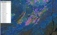
Right: This map compares a retrospective ForWarn image from July 11, 2006 showing a gypsy moth outbreak in Pennsylvania with corresponding gypsy moth polygons delimited by the Aerial Detection Survey.
Forest Service Partners/Collaborators: Western Wildland Environmental Threat Assessment Center
External Partners/Collaborators: NASA Stennis Space Center; Department of Energy Oak Ridge National Laboratory; University of North Carolina Asheville National Environmental Modeling and Analysis Center; U.S. Geological Survey Earth Resources Observation and Science Center
Contact: William Hargrove
