
Searching for persistent landscape patterns and associated wood harvest activity in the southeastern US
Researchers at the Forest Service’s Eastern Forest Environmental Threat Center are working with scientists at Oak Ridge National Lab to monitor landscape change, and a big part of that includes searching for patterns in images from satellites. A special issue in the journal Landscape Ecology will host the results of work developing a tool to find patterns in complex landscapes. Being able to tag image scenes that contain a strong pattern is important for speeding up analysis, which helps researchers recognize and communicate changes rapidly.
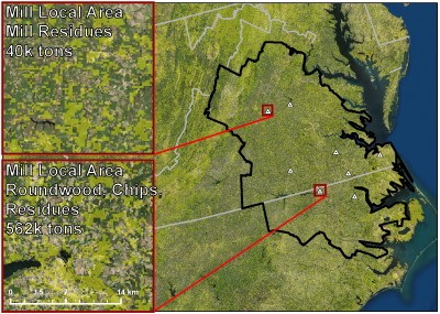 Since 2000 the wood pellet market in the United States has expanded rapidly, due to strong demand from Europe. States throughout the South Atlantic and Gulf region host a number of wood pellet production mills, which utilize everything from sawdust to low grade timber as feedstock. But how will this emerging market and industry impact southern forest landscapes? Researchers at the Forest Service’s Eastern Forest Environmental Threat Center are working with scientists from Oak Ridge National Lab to monitor potential landscape shifts, and a big part of that includes searching for patterns in images from satellites. A forthcoming special issue in the journal Landscape Ecology will host the results of new work developing a tool that finds patterns in complex landscapes. The researchers use images of landscapes that have undergone strongly patterned disturbances, such as timber harvest, to demonstrate the accuracy of the technique at distinguishing those from other changes that occur with a more random spatial signature because they are not focused on any point or along a feature. Being able to tag whether or not an image scene contains a strong pattern speeds up analysis, which helps researchers recognize and respond to changes more rapidly.
Pictured: Satellite map centered on the North Carolina-Virginia border. The yellow shaded overlay shows where vegetation has declined. Cohesive patterns in the yellow squares indicate disturbances such as logging, tornadoes, or wildfire. Analysis helps identify patterns which may at first appear random, and flag them for inspection.
Related publications:
External Partners/Collaborators: Esther Parish, Environmental Sciences Division, Oak Ridge National Laboratory.
Contact: Bjorn-Gustaf Brooks, PhD, Eastern Forest Environmental Threat Assessment Center, bjorn-gustaf.brooks@usda.gov.
