
Forests to Faucets: visualizing forests' role in supplying drinking water across the U.S.
Forests provide drinking water to the nation and protect drinking water supplies. The USDA Forest Service's Forest to Faucets program is a unique tool for understanding and visualizing this ecosystem service, as well as the stressors that threaten it. A new, user-friendly tool integrates maps, hydrologic models, and databases of surface drinking water supply across the country.
 Forests provide numerous ecosystem services that support the U.S. economy and public wellbeing. In particular, forests provide more clean and stable water than any other land use. To better understand this ecosystem service, SRS scientists and partners in State and Private Forestry and the National Forest System have updated the Forests to Faucets mapping and analysis tool, Forests to Faucets Version 2 (F2F2). The study integrated online maps, watershed models, historic and future projections of climate and land use change, and surface drinking water withdrawal data.
The result is a user-friendly tool that lets forest managers identify important watersheds for drinking water supply based on the population served, forest cover, riparian condition, and hydrology. The tool can also assess threats to water supply under current and future climate and land uses conditions, offering information for protecting or restoring forests that are important for drinking water. The F2F2 maps can be incorporated into broad-scale planning, such as State Forest Action Plans, and can help identify vulnerable watersheds for further local analysis. In addition, information generated from F2F2 can be used in other decision support tools to provide spatial information about surface drinking water management. Ultimately, sound management of forests for clean drinking water supply benefits the American public as a whole.
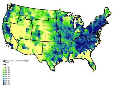
Pictured: The Forest to Faucets program estimates importance of watersheds for surface drinking water across more than 83,000 US watersheds. Those shown in darker blue have higher yield and are serving more people on public water systems drawn from surface water. USDA Forest Service image.
Data products: data products from this study are publicly available, including a story map and a map viewer.
Contact: Ge Sun, Eastern Forest Environmental Threat Assessment Center, ge.sun@usda.gov.
