
In the News
2016
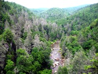
 Over the past decade, countless visitors on southeastern Vermont’s Mount Ascutney have read the words on two interpretive panels describing ongoing research that began as a graduate student’s research project there. Through the years, the panels have faded and weathered, but now they are new again after U.S. Forest Service researchers installed updated replacements in the summer of 2016. "Cleaner Air and Healthier Forests: A Science and Policy Success Story” explains how acid rain is formed when precipitation mixes with nitrogen and sulfur pollutants from automobile exhaust and coal-fired power plants—and how the issue prompted Congressional action and launched efforts to study the impacts in order to develop appropriate policies. Researchers began working on Mount Ascutney in 1987 to understand the relationship between acid rain and damage to forests, in particular the high-elevation, acid-sensitive red spruce forests of the Northeast. Eastern Threat Center biological scientist Johnny Boggs leads the project on Mount Ascutney today. Read more in CompassLive...
 Not surprisingly, a few key issues that influence the sustainability of the nation’s renewable resources are as relevant today as they were at the beginning of the decade: development, climate change, disturbances, and human demand. These themes run throughout the recently published Future of America's Forests and Rangelands: Update to the Forest Service 2010 Resources Planning Act (RPA) Assessment, which provides scientists and managers the latest resource status and trends ahead of the next RPA assessment report due in 2020. Eastern Threat Center research ecologist Kurt Riitters, a longtime contributor to the RPA assessment process, used analyses of post-2010 data to update report sections addressing protected areas and forest fragmentation. “Despite an increase in U.S. forest area, forest fragmentation--especially on private lands--increased between 2001 and 2011,” says Riitters. “Sixteen percent of U.S. lands are protected against human-caused fragmentation to preserve critical ecosystem functions and processes, representing an increase compared to findings from the 2010 RPA report due to better maps and classifications of protected areas.” The RPA report is produced every ten years in response to the 1974 Forest and Rangeland Renewable Resources Planning Act. Learn more…
 U.S. Forest Service Chief Tom Tidwell recently recognized a distinguished cadre of agency employees during the annual Chief’s Awards ceremony. Southern Research Station (SRS) scientist Jim Vose, project leader of the Center for Integrated Forest Science, accepted the “Sustaining Forests and Grasslands” award on behalf of a team of four editors and more than 70 scientific experts who developed a national drought assessment which was published in 2016. Effects of Drought on Forests and Rangelands in the United States: A Comprehensive Science Synthesis provides a scientific foundation for management that promotes well-adapted, resilient forests. The report includes a chapter that discusses the fundamental challenges of detecting and monitoring drought impacts at broad scales, co-authored by Center research ecologists Steve Norman, Frank Koch, and Bill Hargrove. Center research hydrologist Ge Sun also contributed to a chapter that examines drought impacts on water quantity and quality. Read more in CompassLive…
 Though forests and rangelands provide more than half of U.S. water supplies, the long-term impacts of fires, including wildfire and prescribed fire, on annual water yield have been less understood. Three case studies, recently published in the journal Ecohydrology, provide some answers. Eastern Threat Center researchers and partners from the Southern Research Station and U.S. Department of Energy’s Oak Ridge Institute for Science and Education developed an analytical framework to study three watersheds with different characteristics and climates that experienced different types of fire. Their study combined pre- and post-fire streamflow data, fire records, remote sensing images, and computer models in an effort to tease out climate effects and reveal the true impacts of fire on water yield. “The variable magnitude of increased water yield after a wildfire surprised us,” says Center hydrologist Dennis Hallema, the study’s lead author. “Wildfire has a much greater effect on water supply than prescribed burning, because it consumes more vegetation and its heat alters the ground in a way that reduces the amount of water that can infiltrate during a rainstorm.” Read more in CompassLive...
 As 2016 field season participants in the Native American Research Assistantship Program (RAP) provided by the Forest Service and The Wildlife Society, Chase Voirin and Elisha Flores often hiked in remote areas to locate, monitor, and assess any changes in occupancy and reproduction of Mexican spotted owl breeding pairs. Eastern Threat Center biological scientist Serra Hoagland, a co-point of contact for tribal relations for the Southern Research Station, developed and coordinated their work--one of 13 unique research projects providing assistantship opportunities to Native American students since the RAP’s inception in 2015. "The amount of support I received while being involved with this program was more than I could have asked for, and the new experiences I gained exceeded my expectations. This program helped me feel more prepared and opened my eyes to so many possibilities. This was a summer I will never forget,” says Flores. Read more in the Forest Service Office of Tribal Relations newsletter...
 The Eastern Threat Center ForWarn team's efforts to monitor hemlock decline in the southern Appalachian mountains have caught the attention of NASA Earth Observatory, whose mission is to share images, stories, and discoveries emerging from NASA research. Its 'Image of the Day' post for November 15, "Sap-sucking Bugs Threaten Hemlock Forests," describes the hemlock woolly adelgid's threat to hemlock forests and features a map that uses ForWarn data showing the non-native invasive insect's impacts near Mount Mitchell in western North Carolina. The post also features a photo of dead hemlocks* in Pisgah National Forest by Eastern Threat Center research ecologist Steve Norman. ForWarn's satellite-based monitoring system provides weekly maps of changes in vegetation greenness, known as the Normalized Difference Vegetation Index, from data collected by NASA's Aqua and Terra satellites. Staff from NASA Stennis Space Center's Applied Science & Technology Project Office, along with other federal and university partners, have contributed to ForWarn's development.
*Norman's photos of hemlock woolly adelgid-killed trees are also featured inside and on the cover of the November 2016 issue of the Journal of Forestry.

Extreme drought persisted into fall in the Southeast and created the perfect conditions for wildfires to start and spread. Most ignitions were human-caused. Not far from the Eastern Threat Center's Asheville, NC, office, numerous wildfires burned through forest fuels on thousands of parched acres, prompting the governor to declare states of emergency in 25 counties of western North Carolina. “This year stands out as having an unusual, I would even say epic, fire season,” said Center research ecologist Steve Norman, who spoke to a reporter from The Christian Science Monitor exploring the connections between climate and fire in the Southeast. “In some areas, these forests are seeing fires for the first time in decades," he said. "It is a slow process for communities to come to terms with the idea that they are living in a fire prone area." Norman also spoke to a reporter from The Daily Tar Heel about forest health and predicted that fire-adapted, oak-dominated forests are unlikely to be overly impacted by the fires; however, intense smoke and human health may be the most serious concerns in western North Carolina, where the wildfires have triggered "code red" alerts for air quality. Following the wildfires that devastated nearby Gatlinburg, TN, Science magazine’s “News at a glance” feature reported on Norman’s recent analysis of fall fires on federal lands from 1970 to the present. Norman discovered that past fall fire seasons in Tennessee, North Carolina, South Carolina, and Georgia didn’t hold a candle to this most recent season: more area burned in 2016 than burned in the prior 45 years combined! Read the articles in The Christian Science Monitor, The Daily Tar Heel, and Science, and visit the photo gallery to view Norman's photos of smoke effects from wildfires in western North Carolina.
 In the east-central African country of Rwanda, people primarily rely on surface water for drinking, hydroelectric power, and irrigation for subsistence and export crops grown across 70 percent of Rwanda’s land. “Water is critical to the security and well-being of any country regardless of the country’s wealth, but water is everything to the people of Rwanda,” says Eastern Threat Center research ecologist Steve McNulty. In 2011, McNulty and Center researchers Ge Sun and Erika (Cohen) Mack collaborated with the Wildlife Conservation Society and the Rwanda Agricultural Board to perform a rapid assessment of Rwanda’s water resources using the Water Supply Stress Index (WaSSI) model, now described in a recently published case study. Rwandan officials received the assessment results and now have the ability to use WaSSI themselves to see how changes in land cover, leaf area, and current and future climate can affect runoff and surface water supplies for watersheds and sectors across the country. Read more in CompassLive...
 Scientists today work in a variety of research environments, each presenting unique benefits as well as challenges. Eastern Threat Center research ecologist Frank Koch (pictured) typically spends his working day in an office where he models and evaluates risks associated with invasive species, a research environment that offers no shortage of collaboration opportunities. For the second in a series of articles providing insight into the lives of scientists, Entomology Today interviewed Koch and three others who work in the field, laboratory, and classroom to gain insight into their development as specialists--in both subject matter and their chosen research environment. Read the article...
 With more than 40 principal investigators (PIs) and many other contributors representing universities and federal agencies across the Southeast, the PINEMAP project is one of the largest collaborations in which Eastern Threat Center research ecologist Steve McNulty has taken part. “It has been a great partnership,” said co-PI McNulty, “not only in terms of its size but also its achievements.” PINEMAP was recently honored by the USDA National Institute of Food and Agriculture (NIFA) with the Partnership Award for Mission Integration of Research, Education, and Extension. Project Director Tim Martin (University of Florida) accepted the award during an October 6 ceremony in Washington, DC, where USDA officials recognized PINEMAP “for enabling Southern pine landowners to manage forests for increased carbon sequestration and adopt forest management approaches that increase forest resilience and sustainability.” Ge Sun, Eastern Threat Center research hydrologist, and Asko Noormets, North Carolina State University scientist working with the Center, are also co-PIs on the PINEMAP project, now in its final year. Read the NIFA news release.
 Nearly 30,000 insect enthusiasts and bug-curious people recently landed at BugFest 2016, an annual event held in Raleigh, NC, and sponsored by the North Carolina Museum of Natural Sciences. Adding to their journey through bug-filled exhibits, crafts, games, activities, and cuisine were Forest Service representatives from the Eastern Threat Center, Southern Research Station, and Uwharrie National Forest, who staffed a “Bad Bugs in the Woods” booth highlighting invasive insects threatening eastern forests. Visitors at the booth learned about such "bad bugs" as the emerald ash borer, Asian longhorned beetle, and hemlock woolly adelgid, as well as the redbay ambrosia beetle and walnut twig beetle, both associated with fungal diseases. "Many were amazed that these tiny insects could kill a tree," says Erika Mack, a Center resource information specialist at the booth. Mack, along with Center research ecologist Frank Koch and biological scientist Michael Gavazzi also helped young visitors use their fingerprints to craft ants, beetles, butterflies, and caterpillars. BugFest returns in September 2017.
 Some disturbances come and go, leaving forests no worse for the wear. Other times, disturbance damage causes longer lasting effects on forests when dieback or mortality results. When viewed from above with coarse resolution remote sensing, such as with satellite imagery or aerial surveys, canopy impacts can appear similar whether disturbance damage is fleeting or more enduring. How can managers gauge the true impacts of forest disturbance on forest growth and productivity? Eastern Threat Center researchers behind the satellite-based ForWarn tool have developed new Seasonal Duration map products that distinguish short-lived disturbances from lasting disturbances. “ForWarn‘s Seasonal Duration products record the count of weekly monitoring periods that fell below a three percent drop in vegetation greenness compared to the prior year,” explains Bill Hargrove, Eastern Threat Center research ecologist and lead ForWarn researcher. “These maps provide a simple way to identify areas that have experienced long lasting change that are easily overlooked due to the low magnitude of the disturbance or persistent cloud cover during the growing season.” Read more in CompassLive...
 The Wildlife Society (TWS) is an international organization whose mission is to inspire, empower, and enable its 10,000 members to sustain wildlife through science-based management and conservation -- members like Eastern Threat Center biological scientist Serra Hoagland, who has been active with TWS since 2010 when she served as President of a student chapter she launched at the University of California, Santa Barbara. Hoagland recently received her PhD from Northern Arizona University, and as a Forest Service researcher, Southern Research Station co-point of contact for tribal relations, and TWS member involved with the Native People’s Wildlife Working Group, she is also helping others pursue careers in the wildlife field. TWS recognizes her as a 'rising star' in an article in the September/October issue of The Wildlife Professional magazine that highlights Hoagland's early wildlife experiences, education and career path, research assessing Mexican spotted owl populations and habitat, role as mentor, and passion for connecting tribal knowledge and wildlife science. Read the article...
 A number of scientists agree that Earth has entered a new epoch: the Anthropocene. In this era dominated by humans and characterized by their impacts on the environment, including drastic increases in the amount of atmospheric carbon dioxide and subsequent changes in climate, managers face substantial challenges on forested lands and watersheds--critical sources of drinking water. Eastern Threat Center research hydrologist Ge Sun and Southern Research Station project leader Jim Vose co-edited a special issue of the journal Forests that examines the interactions among forests, water, climate change, and humans and covers topics such as soil moisture, wildfire, streamflow, land use, and modeling studies. The issue also includes an article by Sun and Vose about the interactions between emerging global threats and forest water resources and ecosystems. “A key question is whether existing strategies for protecting water resources will be relevant to future conditions,” says Sun. “Managers need flexible tools that account for thinning, prescribed fire, and other management strategies.” Read more in CompassLive...
 Of all the interacting organisms that make up an ecosystem and determine the benefits it provides, people may be the most dynamic and influential. “Across Appalachian mountain landscapes, these benefits, or ecosystem services, depend not just on the types of ecosystems present, but also on how people use the benefits, and who calls these ecosystems home,” explains Lars Pomara, an Eastern Threat Center research ecologist who has collaborated with the Appalachian Landscape Conservation Cooperative on the Ecosystem Benefits and Risks project. The project website—launched earlier this year as a source of regional resources and tools for planners, managers, and interested publics—now includes ‘The Human Landscape,’ a special section that addresses the social dimensions of ecosystem services. Pages dedicated to Demographics and Social Values, Economics and Business, and Land Use synthesize information from a number of scientific studies and provide links to references for further reading. The companion Conservation Atlas allows for visual exploration of the issues through maps detailing regional incomes and economic activity, housing and development trends, population changes, and much more. Additional data and maps are forthcoming, says Pomara.
 Growing up near the Eldorado National Forest in California, Serra Hoagland had an early fascination with open spaces and a love and respect of the animal life that inhabits them. Now living in Flagstaff, Arizona, and working as an accomplished scientist for the Eastern Threat Center, she is cutting a path for other Native Americans seeking to work in her field. A woman of many pursuits and interests, Hoagland is also an expert hunter and surfer. Learn more about Hoagland's life and work from the U.S. Forest Service's 'Faces of the Forest Service' feature.
 Everyone can understand the importance of a yearly checkup for monitoring one’s general health and wellbeing. Regular “checkups” are also necessary to gauge the overall health and monitoring needs of U.S. forests, so managers, scientists, and decision makers look to the U.S. Forest Service’s annual Forest Health Monitoring (FHM) national report to gain insights into issues facing forests across the landscape. The Southern Research Station recently published Forest health monitoring: national status, trends, and analysis 2015, the 15th in a series of these reports that summarize forest conditions from the prior year. “This is a big report that includes a lot of information. The scientists who contribute to it quantify the status of, changes to, and trends in a wide variety of broadly defined indicators of forest health, including fragmentation, plant biodiversity, soils, down woody materials, and crown conditions, among others,” says Kevin Potter, a North Carolina State University (NCSU) scientist cooperating with the Eastern Threat Center who co-edited the report with fellow NCSU scientist Barb Conkling. “The main objective is to identify ecological resources whose condition is deteriorating over large regions – which requires consistent, large-scale, and long-term monitoring.” Read more in CompassLive...
 Precipitation, water yield from forests, and forest growth and productivity generally increase from west to east across the United States. Shifts in temperature and precipitation associated with climate change may not necessarily alter these general west-to-east trends, but U.S. Forest Service and university researchers do anticipate great variability in how watersheds respond to increasing temperatures and the extreme precipitation and drought events expected in the future. For a recently published study, researchers compared past (1979-2007) and future (2031-2060) watershed dynamics using a combination of two computer models—the Water Supply Stress Index Model, a tool that predicts water and carbon balances from the watershed to national scale, and the Weather Research and Forecasting (WRF) Model, which simulates atmospheric conditions and allowed researchers to “downscale” global climate change data to make them relevant to U.S. regional areas. “When we looked at the U.S. as a whole, we found that future precipitation and temperature could follow a similar west-to-east pattern as the 1979 to 2007 baseline period,” says Eastern Threat Center research hydrologist Ge Sun, a co-author of the study. “But for each watershed, these two climate variables will likely increase or decrease by different magnitudes in the future, leading to different responses in terms of water yield and ecosystem productivity.” Read more in CompassLive...
Annual Forest Health Monitoring (FHM) reports summarize the status, trends, and analyses of the nation's forest resources. The recently published 2015 report, edited by Eastern Threat Center cooperating scientists Kevin Potter and Barb Conkling, features chapters authored by Center scientists and cooperators that discuss a variety of forest health issues, including patterns of insect and disease activity, forest fire occurrence, drought and moisture surplus, tree mortality, and forest fragmentation. The report also includes summaries of recently completed Evaluation Monitoring projects--FHM-funded efforts to determine the extent, severity, and causes of forest health changes as seen through Detection Monitoring activities.
 A long-term dataset that spans 10 sites and six states revealed that longleaf pine operates on a seed production cycle that takes roughly 3 years – sometimes 4 – to complete. Eastern Threat Center research ecologist Qinfeng Guo and colleagues examined the cone production cycle in an earlier study, and recently published a new study showing that climate influences the cycle, although its effects are quite complex. The study reveals that longleaf pine trees have begun producing more cones on some sites in recent years and that the increase in cone production coincides with greater climatic variability, especially temperature fluctuations. Understanding the connections between cone production and climate will require further investigation. Read more in CompassLive...
 Serra Hoagland has worked part-time as a biological scientist with the Eastern Threat Center while completing course work at Northern Arizona University (NAU) and her Ph.D. project: an assessment of the Mexican spotted owl (a threatened species) and forest treatments on tribal and adjacent national forest lands. Center Director Danny Lee and several Center scientists have supported Serra in this ongoing research to address issues of forest health and wildland fire risk—findings that are important for the Forest Service as well as tribal communities. In May, she became the first Native American female to receive a Ph.D. in forestry from NAU. NAU President Rita Hartung Cheng mentioned Serra and her achievements during a commencement speech. Read more in CompassLive...
 Researchers working at the Eastern Threat Center's office in Asheville, North Carolina, are just a short drive away from one of the most biodiverse places on the planet: the Great Smoky Mountains National Park, which straddles 800 square miles of western North Carolina and eastern Tennessee. Although they and nearby collaborators at Oak Ridge National Laboratory (ORNL) have visited the park many times, they are now seeing its forest cover in a way they’ve never seen it before. Along with researchers from the University of California, Berkeley and the U.S. Fish and Wildlife Service, they’ve devised a technique for crunching large volumes of data from Light Detection and Ranging, a remote sensing method known as LiDAR, to map and characterize the vertical structure of the forest canopy in the Tennessee side of the park. "Vertical distribution of the forest structure is a vital characteristic of the forest itself, as well as an important characteristic of the forest habitat for many species of plants, birds, and other animals,” says Center research ecologist Bill Hargrove. As the Great Smoky Mountains National Park and other U.S. landscapes face a variety of threats, forest structure maps can highlight changes in the richness and distribution of habitat to help forest and natural resource managers monitor, manage, and conserve plant and animal species. Read more in CompassLive...
 For many years, minority landowners have wanted to take steps to maximize the benefits of their forested land but have not known how to go about doing it. A recent workshop held in Meridian, MS, and co-hosted by the Southern Research Station (SRS) and Minority Landowner Magazine (left) provided the first step for many landowners to move beyond this limitation and begin actively managing their forests and generating a regular income. Eastern Threat Center biological scientist Johnny Boggs was among the workshop presenters who addressed topics ranging from an overview of SRS to land ownership, forest threats, non-timber forest products, forest inventory and analysis, and financial assistance programs. “It was a great opportunity to share with minority landowners how our research has improved land management and forest health and productivity across the South," says Boggs. “I have heirs’ property in my own family, so I could certainly relate to many of the landowners in the room who want to know more about how to generate revenue from their land, how to retain land across generations, and how to work through family dynamics when trying to sell timber." Read more in CompassLive...
 Water resources in southeastern forests are stressed from urban sprawl, increased water usage, climate variability, and, increasingly, wildland fire. Last year, 2015, was a record year for wildland fire with more than 10 million acres burned in the U.S. Many research projects currently focus on sustaining forest ecological functions and forests’ ability to supply water for future generations, including a Joint Fire Science Program-funded study on the effects of wildland and prescribed fires on water quantity across the landscape. Eastern Threat Center research hydrologists Ge Sun and Dennis Hallema, who have been conducting this study since 2014, recently presented an invited seminar on their results to fellow researchers at the Joseph W. Jones Ecological Research Center in southwestern Georgia, where the Flint River has experienced profound effects of water stress due to increasing drought and irrigation demands for agriculture. Since the 1970s, water yields have declined rapidly in the region, resulting in lower streamflow in the Lower Flint River Basin. Read more in CompassLive...
The Appalachian Landscape Conservation Cooperative (LCC) and the U.S. Forest Service are releasing products from the first phase of an ongoing study assessing benefits of and risks to the region's "ecosystem services" -- natural assets valued by people such as clean drinking water, outdoor recreation, forest products, and biological conservation. A wealth of data, maps, and other knowledge on ecosystem services and risks to their sustainability are now available on the “Ecosystem Benefits and Risks” website within the Appalachian LCC Web Portal. The new website provides regional resources and tools for planners, managers, and the interested public across the Appalachians. Eastern Threat Center research ecologist Lars Pomara said the goal of the research is to “link the values that society places on these benefits from nature with threats to their current and future sustainability to inform future resource management decisions and enhance conservation.” Read more in CompassLive, and download the “Ecosystem Benefits and Risks” fact sheet.
 The Forest Service Forest Inventory and Analysis (FIA) program represents the longest-running and most comprehensive survey of forested land in the United States. Historically focused on timber resources, FIA now also collects information on many forest attributes, including invasive plant species, lichens, soil properties, and carbon storage. These data help scientists and managers understand plant distribution and abundance--useful knowledge for many aspects of preventing, detecting, and managing non-native insect invasions and their aftermath. Eastern Threat Center research ecologist Frank Koch and Southern Research Station FIA deputy program manager James Vogt recently published an article in American Entomologist outlining the important role of FIA data in invasive insect research. Read more in CompassLive...
 After more than a year of planning, local organizers from the Eastern Threat Center were thrilled to finally welcome attendees of the annual meeting of the U.S. International Association for Landscape Ecology (US-IALE), held last month in Asheville, North Carolina. It was the 29th and largest ever US-IALE annual meeting, drawing approximately 500 professionals (including about 40 Forest Service scientists) and students from 22 countries and 42 states. “I think that what makes the annual US-IALE meeting so great is that it is attended by people who believe that the best science comes from the overlaps in scientific subjects — the intersection between multiple disciplines,” says Bill Hargrove, a research ecologist with the Eastern Threat Center and chair of the meeting’s organizing committee. “Because of their common interests, meeting attendees engage in deeper attempts at cross-disciplinary thinking, bridging vocabulary and terminology across subjects. This is one of the unique aspects of the annual US-IALE meeting and why it has been my favorite meeting to attend over the last three decades.” Read more in CompassLive...
 A warmer climate may lead to higher growth and productivity on U.S. national forests and grasslands, but university and U.S. Forest Service researchers say this could reduce quantities of fresh water flowing from most of these lands, even with increases in precipitation. Results were published in Scientific Reports. "The national forests and grasslands managed by the U.S. Forest Service represent only 9 percent of the U.S. land area, but play an important role in providing fresh water that contributes to about 14 percent of the national water supply," says Kai Duan, a North Carolina State University postdoctoral researcher working with the Eastern Threat Center and the study's lead author. "A notable tradeoff between water yield and productivity is expected to intensify under higher greenhouse gas emissions and associated climate change in the future, posing greater challenges to managing these lands and balancing these important ecosystem services." Read the news release, along with media coverage from Motherboard.
 Longleaf pine ecosystems once covered an estimated 80 to 90 million acres across the southeastern United States, but by 1995 populations declined due to timber harvesting, land use change, and fire suppression, with only about 2.4 million acres remaining. Natural regeneration is challenging because longleaf pine trees produce seeds sporadically (it can take almost 3 years for a mature longleaf pine to produce viable seeds), and many factors can adversely impact cone and seed development. Eastern Threat Center research ecologist Qinfeng Guo and colleagues explored cone production on six study sites across the Southeast, as well as the relationships between cone production and local climate. They detected shifts to a new pattern of cone production at five of the six sites and found that the complex patterns of cone production were highly correlated to air temperature and precipitation. “Our results indicate that in general, past climate fluctuations have not affected the relationship between climate and cone production,” says Guo. “Whether this relationship will persist under the increasingly rapid rates of climate change is unknown.” Read more in CompassLive...
 In your day-to-day life, what obstacles prevent you from achieving your goals at work? Upon reflection, each person may have a different and personal response to this question. When posed to a group of women with common work environments, some similar challenges emerge. Three professionals from The Wildlife Society’s “Women of Wildlife” (WoW) committee engaged this question in conversation during a panel discussion at the 49th Joint Annual Meeting of the Arizona and New Mexico Chapters of The Wildlife Society and the Arizona-New Mexico Chapter of the American Fisheries Society, held last month in Flagstaff, Arizona. Despite occupying the multi-day meeting’s final time slot, the audience for the panel discussion was large, energetic – and not just women. “It was an amazing turnout of women and men, and our panel fostered great discussion among the audience,” says Serra Hoagland, a biological scientist with the Eastern Threat Center, PhD candidate at Northern Arizona University, and an early career age group panelist.“Discussions like this are so helpful to start the dialogue and gain momentum and support for women and other underrepresented groups." Read more in CompassLive...
 In western North Carolina and eastern Tennessee, one doesn’t have to look too hard to see dead and dying hemlock trees resulting from invasions of the non-native hemlock woolly adelgid (HWA). With a new map, the Eastern Threat Center research team behind the satellite-based ForWarn monitoring and assessment tool has shown a landscape-scale perspective of the extent and westward movement of evergreen forest decline, including hemlock forests, in the Southern Appalachians. Using an approach that removes the occasional snowpack and winter weather factors, researchers mapped the change in vegetation greenness in winter (when deciduous trees are dormant and evergreen species are most visible) between 2000 and 2014. The declines in winter greenness revealed are due to impacts from HWA, logging, or fire, but most of the areas of decline correspond to known epicenters of HWA-caused tree mortality. “Many think of eastern hemlock as primarily a riparian species in the Southern Appalachians, but it is also common on high elevation north slopes where the decline has been profound,” says Center research ecologist Steve Norman. Norman and Center research ecologist and lead ForWarn researcher Bill Hargrove recently presented the map as a potential planning tool at a meeting of state and private forestry professionals and landowners at the North Carolina Hemlock Woolly Adelgid Bio-Control Forum. The meeting was sponsored by the Hemlock Restoration Initiative, whose Coordinator, Margot Wallston, previously worked on a ForWarn hemlock decline mapping project while studying at the University of North Carolina Asheville.
 Recent research indicates that invasive plants can be found in nearly half of the forests of the eastern United States, raising concerns about the sustainability of these ecosystems and the benefits and services they provide. The good news is that some eastern forests seem to have a natural, biotic ability to resist invasion. To understand why, a team of U.S. Forest Service and university researchers, including Center cooperating scientist Kevin Potter and research ecologist Qinfeng Guo, looked for clues within “big data” from the Forest Inventory and Analysis (FIA) program. Their findings, recently published in Landscape Ecology, suggest that live tree biomass and evolutionary relationships among tree species are key factors for invasion resistance. Researchers also reported that greater evidence of invasion resistance emerged in patterns seen in some forests of the Upper Midwest and in and around the Appalachian Mountains. Read more in CompassLive...
 In a changing climate, management actions could help or harm forests facing drought and related disturbances, including wildfires and insect outbreaks. To gain a scientific foundation for management that promotes well-adapted, resilient forests, land managers can look to a new national drought report resulting from U.S. Forest Service and university collaboration. Eastern Threat Center research ecologists Steve Norman, Frank Koch, and Bill Hargrove co-authored a chapter in the report that discusses the fundamental challenges of detecting and monitoring drought impacts at broad scales, describes strengths and weaknesses of existing approaches for doing so, and presents methods for combining these approaches with supporting datasets to assess drought impacts across landscapes. Center research hydrologist Ge Sun also contributed to the report in a chapter that examines drought impacts on water quantity and quality and how management options can mitigate negative effects of climate change on water resources. Learn more about the national drought report...
 Between 2000 and 2012, the world lost more forest area than it gained, according to U.S. Forest Service researchers and partners who estimated a global net loss of 1.71 million square kilometers of forest—an area about two and a half times the size of Texas. Furthermore, when researchers analyzed patterns of remaining forest, they found a global loss of interior forest—core areas that, when intact, maintain critical habitat and ecological functions. “In addition to the direct loss of forest, there was a widespread shift of the remaining global forest to a more fragmented condition,” says Kurt Riitters, Eastern Threat Center research ecologist and team leader and the lead author of a study describing the phenomenon, published in the January 2016 issue of Landscape Ecology. “Forest area loss alone underestimates ecological risks from forest fragmentation. The spatial pattern of forest is important because the same area of forest can be arranged in different ways on the landscape with important consequences for ecosystem processes.” Read the news release, along with media coverage from Mongabay and The Conversation.
 Students have a new resource for understanding technology that monitors land, water, sky, and space from aircraft and satellites. Eastern Threat Center research ecologist Frank Koch is a co-author of Principles of Applied Remote Sensing, one of the first textbooks to cover many aspects of remote sensing for both graduate and undergraduate students, including data acquisition, tools, applications, international laws and policy, and future trends. According to the publisher, “Remote sensing is an exciting, dynamic technology that is transforming the Earth sciences…as well as the practices of agriculture, disaster response, engineering, natural resources, providing evidence in legal cases and documented humanitarian crises, and many other fields. Increasingly, understanding of these techniques will be central to a number of disciplines, particularly as the technology advances.” Visit the Springer website to learn more.
 A growing world population demands more wood and fiber, much of which is harvested from intensively managed forests. In these forests, tree growth as well as post-harvest land cover changes can be easy to see, but an invisible part of the management process has captured the attention of scientists and university collaborators with the Eastern Threat Center. Following a study published in the November 2015 issue of Forest Ecology and Management, researchers concluded that high forest productivity in managed forests often comes at the expense of carbon storage in soils. After reviewing current global datasets and comparing characteristics of managed and unmanaged stands, “We discovered that carbon is allocated differently between plant parts in managed forests, with relatively greater aboveground productivity and lower belowground carbon storage,” says Asko Noormets, a North Carolina State University scientist working with the Eastern Threat Center and the study’s lead author. “The greater frequency of harvests and physical disturbance of soils in managed forests results in higher soil respiration and carbon loss.” Read more in CompassLive...
 Invasive plants are increasingly altering the structure and function of our natural environment, and now researchers have determined how far-reaching the problem has become. According to a study conducted by Southern Research Station and university scientists and published in the journal NeoBiota, at least one invasive species is present in 39 percent of forested plots sampled nationwide for invasive plants by the Forest Service Forest Inventory and Analysis (FIA) program. Results are provided for all U.S. regions and reveal that a significant portion of the more than 741 million acres of forested land in the United States has been invaded. The researchers created a U.S. map of invasion-intensity to illustrate the extent of the problem and help inform management actions across the landscape. “For this study, our intention was to let people see how large data sets can be used to understand macro-scale issues and monitoring forest invasion. This broad-scale study gives us a wider perspective that one can’t get from local studies,” says Qinfeng Guo, Eastern Threat Center research ecologist and a co-author of the study. Read more in CompassLive...
 In Asheville, North Carolina, a flourishing tourism industry and an influx of new residents is leading to increased development and associated economic and ecological pressures in the city and surrounding areas. These shifting dynamics will provide a fitting backdrop when Asheville hosts landscape ecologists who will examine the theme of “Landscape Change” during the annual meeting of the U.S. Regional Association of the International Association for Landscape Ecology (US-IALE) next spring, organized by the Eastern Threat Center. “We’re thrilled to organize the annual US-IALE meeting, which has not been held in the eastern United States since 2012,” says Bill Hargrove, a Center research ecologist and co-chair of the meeting’s organizing committee. “With the simple theme of ‘Landscape Change,’ we’ll strive to capture the defining characteristic and the inherent nature of our modern world. We’ll discuss the challenges of many aspects of landscape change, and we expect to discover new opportunities for studying these challenges and collaborations to address them.” The meeting will take place April 3-7, 2016. Read more in CompassLive...
« Next Year Previous Year » 2024 2023 2022 2021 2020 2019 2018 2017 2016 2015 2014 2013 2012 2011 2010 2009 2008 2007 2005
