
In the News
2021
 Before Europeans arrived in North America, longleaf pine forest and savannah blanketed some 141,000 square miles of land from modern-day southern Virginia to East Texas. Today, there are roughly 4.7 million acres of longleaf pine across the South, up from a historic low of just more than 3 million acres in the early 1990s. Increasing recognition of the potential for longleaf pine's resilience to climate change is among the reasons for the gathering momentum behind restoration efforts throughout the South.
North Carolina State University professor and Threat Center collaborating scientist Kevin Potter was interviewed for an article in the Christian Science Monitor, pointing out that after long decades of overharvesting, "there's an effort going into maintaining and restoring these stands". "The South is the source of most of the pulp that we use for our paper and, to some degree, the wood that we use to build our houses," says Dr. Potter, a biodiversity expert who researches longleaf pine. The species' deep taproots provide resilience against wind, fire, and drought that may prove vital amid climate change, in comparison with other pines, while it can also support sustainable harvest. And longleaf pine ecosystems support a rich diversity of native plants and wildlife, some of which are threatened or endangered due to the historic loss of this habitat.
Read the article to learn more about the history and ecology of longleaf pine ecosystems, and ongoing efforts to restore them.
Pictured: Caroline Dormon hugs a longleaf pine she called "Ole Granddad" in this undated photo. Ms. Dormon is considered the spiritual founder of the Kisatchie National Forest in central and northern Louisiana. Alexandria Town Talk/AP photo.
The Forest Service and its partners have produced many regional assessments that provide information about conserving habitats, clean water, timber and non-timber resources, and other ecosystem services. Renewed collaboration with National Forests in the Southeast is enabling approaches that pull together information from these many sources to give a full picture of forest landscapes, the threats they face, and how best to conserve the many benefits they provide.
 Recent articles in CompassLive and in the Ecoforesters Newsletter highlighted ecological assessment as a key tool for understanding the role of forests in providing a wide variety of benefits to society. Synthesis of regional assessments can help capture the complexities of whole landscapes while providing clarity to decision-makers when multiple values and management goals are at stake. The Landscape-Level Integration and Shared Stewardship initiative is a regional Forest Service effort to enhance the use of best available science in adaptive landscape management. Scientists engaged in this effort are developing tools that integrate existing assessments to aid in large-scale ecosystem management decision-making.
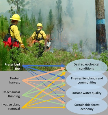
Pictured: A variety of forest management tools are used in Southern landscapes to help achieve a variety of goals. These tools have different impacts, and applying them well depends on rich ecological and societal information. Integrating multiple forest assessment approaches into planning can help in applying the right tools to achieve the best outcomes. USDA Forest Service image.
 On June 4, Ge Sun was named the recipient of the 2021 Icko Iben Multidisciplinary Communications Award, from the American Water Resources Association (AWRA). Established in 1971, this award recognizes persons who have made outstanding contributions in promoting communication among the various disciplines concerned with water resources issues. It honors the late Dr. Icko Iben, a co-founder of AWRA, who during his life contributed extensively toward improving understanding and communication among those involved in the diverse disciplines related to water resources.
Dr. Sun was also included in the Reuters Hot List of influential climate change scientists (#634). Reuters identified 1,000 scientists with the biggest impact on climate change science, considering three measures of science influence related to number of publications, citations, and public outreach. Congratulations Ge!
Researchers from North Carolina State University and the U.S. Forest Service’s Eastern Forest Environmental Threat Assessment Center are tracking natural and managed forests near the coast to see how the forests respond to changing climate conditions. The research is covered in an ongoing NC State News series about how sea level rise impacts people and environments.
In a study published in Agricultural and Forest Meteorology, the researchers, including lead author Maricar Aguilos at NC State, reported that trees in North Carolina coastal forests were dying at an increasing rate. In 2009, they found about one and a half dead trees per acre; that increased to more than six per acre by 2017. The researchers believe the dying trees are a contributing factor to one of their key findings: the forest had become a net source of carbon. Their findings suggest the forest is both a casualty of climate change, and a contributor.
An earlier entry in the NC State series covered additional aspects of the group's research on coastal forests, climate change, and water.

“We need long-term studies to better understand the carbon and water processes in forests so we can figure out how to properly manage our wetland resources,” said study collaborator and director of EFETAC, Ge Sun.
Read the full story from NC State University News
Read the full research article in Treesearch
Most of the 19 experimental forests of the Forest Service's Southern Research Station were founded in the 1930s or 1940s. Over the past five years, they have become something new: the SRS Experimental Forest Network. “Each experimental forest is a regional asset,” says Stephanie Laseter, a USDA Forest Service scientist and network co-lead. Johnny Boggs is also a co-lead. “When part of a network, each forest becomes more valuable,” says Boggs. “The Experimental Forest Network allows ideas, people, data, and resources to flow across each forest.”

A recent analysis by Ge Sun and Erika Mack compared precipitation, water yield, and evapotranspiration across sites on all experimental forests in the Network. The work is a foundational step towards understanding the sites that make up the network and will make studies that span multiple experimental forests even more useful. Rabio Olatinwo and JT Vogt have also completed analyses on drought indices across the Network. Several cross-site studies are already underway, and some are nearing completion.
Read the full CompassLive article.
Read more on the Experimental Forests Network.
Climate change is increasing the frequency and severity of hurricanes. Southern forest, farm, and ranch landowners need to better prepare and plan for hurricane impacts. The USDA Southeast Climate Hub surveyed hurricane preparedness and recovery resources and identified a need for centralized guidance that is complete and consistent.
The Hub teamed up with university extension and other USDA partners to develop a centralized resource for landowners. Led by director Steven McNulty and coordinator Michael Gavazzi, the authors produced a series of 23 Hurricane Preparation and Recovery guides focused on the most economically important commodities for coastal states in the southeastern U.S. including timber, livestock, row crops, aquaculture, and more. The guides provide a one-stop shop for landowners or managers seeking resources for hurricane preparedness, recovery, and long-term resilience. The Southeast Climate Hub intends to periodically update the guides to keep them current.
Read the complete CompassLive article.
Access the hurricane preparedness and recovery guides.

« Next Year Previous Year » 2024 2023 2022 2021 2020 2019 2018 2017 2016 2015 2014 2013 2012 2011 2010 2009 2008 2007 2005
