
2014 Research Highlights
How Fragmented are the Nation's Forests?
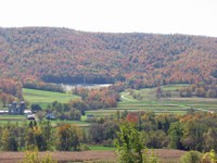 Every ten years, the USDA Forest Service Resources Planning Act (RPA) Assessment provides reliable information on the status, trends, and projected future of the nation’s renewable resources. The spatial patterns of forest, grass, and shrub land cover were assessed as part of the 2010 RPA Assessment, using the 2001 National Land Cover Dataset. Using protocols developed by an Eastern Threat Center scientist, new landcover maps from 2006 and 2011 are being used to update the 2015 RPA Assessment of overall forest fragmentation, the loss of forest interior conditions from 2001 to 2011, within ecological sections of the conterminous United States. The information is being combined with additional field plot data from the Forest Inventory and Analysis Program to expand the comparative assessment of forest fragmentation to 125 major forest types.
Forest Service Partners/Collaborators: R&D Quantitative Sciences; R&D Forest Inventory and Analysis.
External Partners/Collaborators: North Carolina State University
Contact: Kurt Riitters, (919) 549-4015, kurt.h.riitters@usda.gov
Photo by Steve Norman, USDA Forest Service.
