
Mapping crops within the growing season across the United States
The ability to map growing crops may permit near real-time monitoring of the health status and vigor of agricultural crops nationally. New research uses satellite remote sensing to map all acres planted in major crop types, during the current growing season—offering distinct advantages over traditional approaches.
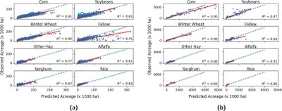 The United States lacks a nationwide crop type map made during the current growing season. The USDA Crop Data Layer (CDL) is an authoritative source, but the CDL is not produced until the next year following the current growing season. To enable within-growing-season national mapping, a research team including Southern Research Station scientists paired previous years of CDL ground truth data with images from MODIS satellite sensors. A statistical model used time series of the image-based NDVI vegetation index across the growing season to group similar regions that might indicate a crop type, then assign labels to those regions based on known crop types from the CDL. This was done separately within different ecoregions across the country, to reduce classification errors from variations in climate, agricultural practices, and growing conditions. The model was trained on the years 2008–2014, then tested on 2015–2018. Accuracy was around 70% across the major corn, soybean, and winter wheat producing areas. Accuracy for major crops improved with time as they grew, reaching 90% accuracy by the end of August—with earlier dates for corn and soybeans in the central regions of the Corn Belt. Using this model, these national crop type maps can now be produced for the current growing season, as early as the end of April for most crop types, and accuracy increases later in the year.
